A soybean harvested in Brazil can spend much of its journey simply getting to the ocean. It may travel by truck, rail or barge from an inland farming region to an export terminal, then cross thousands of miles of ocean before reaching a processor in Asia. Grain grown in the central United States faces its own long transportation chain, often traveling along the Mississippi River system before being loaded onto an oceangoing vessel.
These journeys illustrate a basic feature of the modern food system: production and consumption are often separated by enormous distances. Countries rely on international markets for wheat, corn, rice, soybeans, vegetable oils and other agricultural commodities. Farmers, meanwhile, may depend on internationally traded fertilizer and energy inputs to produce the next harvest.
Moving all of those products requires physical infrastructure. Despite the enormous scale of global agricultural trade, much of it eventually converges on a limited number of transportation corridors.
These critical links are often called trade chokepoints. They include narrow straits and canals as well as ports, rivers, rail networks and highways. Their importance comes from concentration: when unusually large volumes of cargo depend on a particular piece of infrastructure or geographic passage, trouble there can affect supply chains far beyond the immediate area.
A 2017 Chatham House study examined 14 chokepoints considered strategically important to global food trade. Using 2015 trade data, researchers estimated that 55% of internationally traded wheat, maize, rice and soybeans passed through at least one maritime chokepoint.
Those numbers describe trade patterns more than a decade ago and should not be treated as current market shares. Nevertheless, many of the transportation corridors identified by the study remain important to agricultural trade today.
Narrow waterways carrying enormous volumes
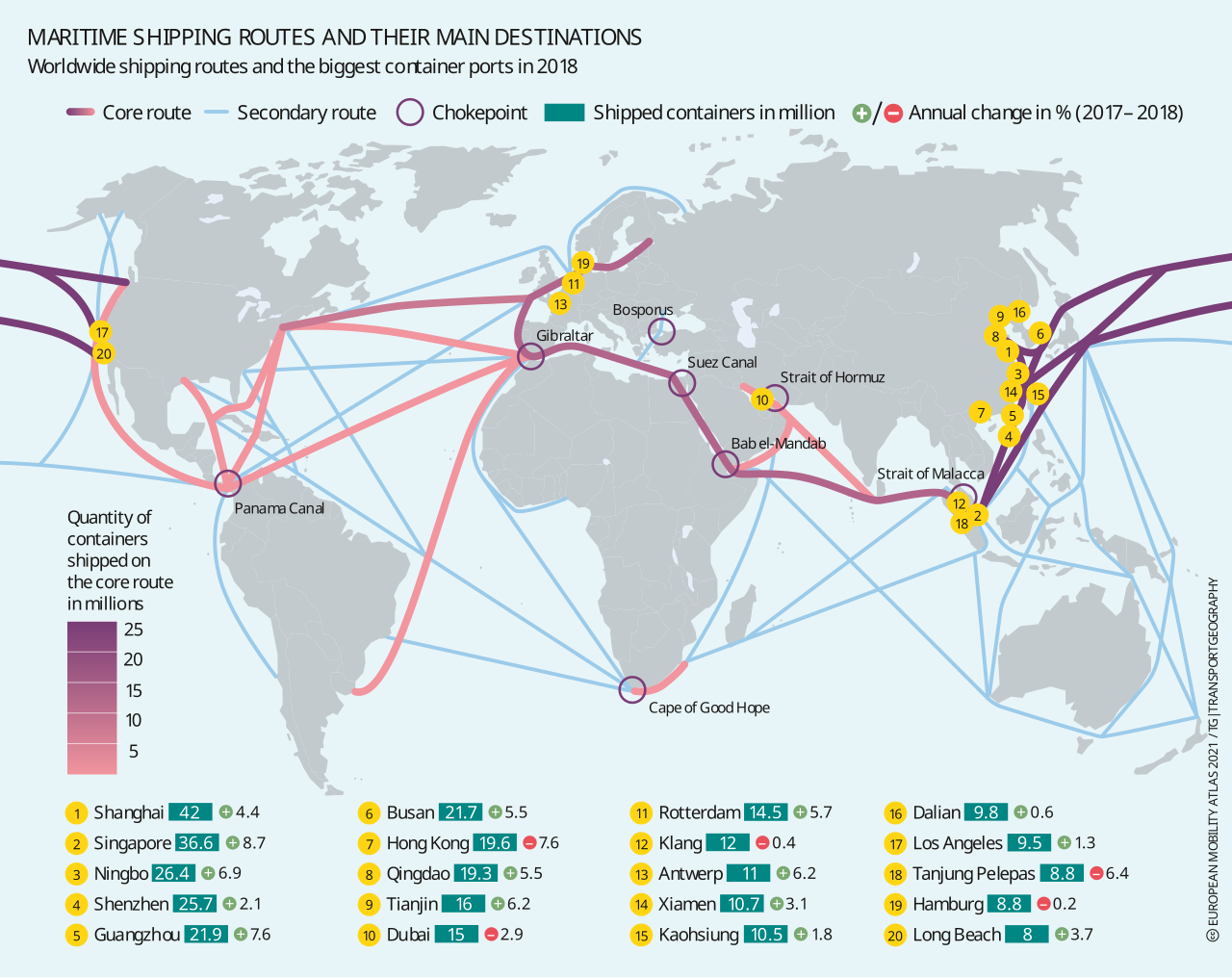
The Strait of Malacca lies between the Malay Peninsula and the Indonesian island of Sumatra. Its location makes it an important connection between the Indian Ocean and the waters leading toward East and Southeast Asia.
Agricultural commodities form part of that traffic. Chatham House estimated that in 2015 the strait carried more than one-quarter of internationally exported soybeans and about one-fifth of internationally traded rice. Asian demand, particularly for soybeans used to produce animal feed and vegetable oil, helps explain the importance of this route.
Malacca is not the only possible passage through the region. Ships can use other waterways through the Indonesian archipelago, but alternatives may require additional sailing distance or may be unsuitable for some vessels.
That illustrates an important point about chokepoints. Their disruption does not necessarily make transportation impossible. Instead, it can force cargo onto routes that take more time, cost more money or have less capacity.
Another important corridor links the Mediterranean and Indian Ocean through the Red Sea. The Suez Canal forms its northern connection, while Bab el-Mandeb sits at the other end of the Red Sea. Together, these waterways make it possible for vessels traveling between Europe and Asia to avoid the much longer trip around Africa.
Its vulnerability became particularly visible after attacks on commercial vessels in and around the Red Sea increased in late 2023. Shipping companies responded by diverting many vessels away from the region and sending them around the Cape of Good Hope.
By mid-October 2024, UN Trade and Development reported that average traffic through the Suez Canal had fallen to about 33 ship transits per day, 55% below the level recorded one year earlier.
Trade continued despite the disruption, but the geography changed. Ships traveling around Africa had farther to go, increasing voyage times and fuel consumption. Longer journeys also kept vessels occupied for additional days, reducing the amount of shipping capacity available elsewhere.
The Black Sea shows how a different kind of disruption can affect agricultural transportation.
Russia and Ukraine are both major agricultural exporters, and Black Sea shipping reaches the Mediterranean through Türkiye’s Bosporus and Dardanelles, collectively known as the Turkish Straits.
Russia’s full-scale invasion of Ukraine in 2022 severely disrupted Ukrainian maritime exports and contributed to uncertainty in international grain markets. The United Nations and Türkiye subsequently brokered the Black Sea Grain Initiative. During its operation, nearly 33 million metric tons of grain and other food commodities were shipped from three Ukrainian ports before the agreement ended in July 2023.
Ukraine later established another maritime export corridor while continuing to move agricultural products by rail, road and through ports along the Danube.
War has continued to threaten those routes. Attacks on ports and shipping can reduce the ability of Black Sea terminals to operate normally and force exporters to rely more heavily on alternatives. But those alternatives have limits of their own. Moving additional cargo toward the Danube, for example, can put greater pressure on river ports and connecting infrastructure.
This is another characteristic of transportation chokepoints: congestion can migrate. When cargo is diverted away from one constrained route, another route can become the new bottleneck.
Drought can disrupt trade too
Chokepoint problems do not always begin with war or political conflict. Sometimes the limiting factor is water.
The Panama Canal provides one of the clearest examples.
Unlike a sea-level canal, Panama’s system of locks depends heavily on freshwater. Severe drought during 2023 reduced reservoir levels and led the Panama Canal Authority to limit vessel traffic.
USDA reported that daily transit capacity fell to 24 ships in early 2024, compared with roughly 38 to 40 under normal operating conditions.
The restrictions affected agricultural shipping because the canal is one possible route for U.S. grain exported from Gulf Coast ports to customers in Asia.
USDA found that some bulk grain vessels instead traveled toward Asia using the Suez route. That option could add more than 5,000 nautical miles and more than two weeks to a voyage. Once security conditions in the Red Sea deteriorated as well, vessels avoiding both Panama and the Red Sea faced the still longer journey around Africa.
Water levels at Panama subsequently recovered, allowing transit restrictions to be relaxed.
The disruption was temporary, but its effects demonstrated how rainfall in one watershed can influence shipping decisions across much of the world.
Rivers can create similar vulnerabilities.
The Mississippi River system connects agricultural regions across the central United States with export facilities near the Gulf of Mexico. Barges provide a relatively inexpensive way to transport large quantities of corn, soybeans and wheat, and USDA estimates that inland waterways carry about 65% of U.S. grain exports.
Low water reduces that advantage.
When river levels fall, barges may need to carry less cargo so they sit higher in the water. Operators can also reduce the number of barges assembled into a tow. Both measures help vessels navigate safely but reduce the amount of grain that can move at once.
During the 2025 harvest season, low water again caused navigation restrictions following an exceptionally dry August in the Ohio River Basin.
Even with those difficulties, total Mississippi River System barge grain movements finished 2025 about 11% above their 2024 level, helped by strong corn exports. The result demonstrates that a transportation constraint does not necessarily mean trade volumes will decline overall. It can instead make moving those volumes more difficult or expensive.
Brazil’s long journey from farm to port
Brazil illustrates another kind of transportation vulnerability.
It is one of the world’s largest soybean producers and exporters, yet many of its major growing areas are deep in the country’s interior. Before crops can be shipped overseas, they may first have to cover substantial distances by highway, railway or inland waterway.
The scale of this movement is enormous. By the end of June 2025, Brazil had exported a record 64.9 million metric tons of soybeans, according to USDA. China was by far the largest destination, receiving nearly three-quarters of those exports.
Getting such volumes from farms to ships requires an extensive transportation network. Brazil has invested in northern export corridors and other infrastructure that give producers more options for reaching international markets. At the same time, traditional gateways such as Santos continue to handle large agricultural flows.
More routes can make the system more resilient, but they do not eliminate logistical constraints. Highways can become congested, railways have finite capacity, river transportation can be affected by water conditions, and export terminals can handle only so many vessels and so much cargo at once.
Brazil therefore demonstrates that an agricultural chokepoint does not have to be a narrow passage between two bodies of water. A bottleneck can develop far inland, where crops enter a transportation corridor, or at the coastal terminal where enormous volumes must be transferred onto ships.
Food is not the only thing that has to move
The global food system depends on more than shipments of harvested crops.
Fertilizer must often travel through international supply chains before farmers can grow those crops in the first place.
Major fertilizer-producing and exporting regions include Russia, North Africa and the Middle East. As a result, fertilizer shipments can depend on some of the same maritime passages used by agricultural commodities.
One of the most important is the Strait of Hormuz, the narrow outlet connecting the Persian Gulf with the wider Indian Ocean transportation network.
A substantial share of internationally traded fertilizer depends on this passage. That concentration means serious disruption around Hormuz can affect agricultural producers far beyond countries bordering the Persian Gulf.
The consequences of interrupting fertilizer shipments can also unfold differently from the effects of delaying a cargo of wheat.
A delayed grain shipment creates an immediate transportation problem. A fertilizer shortage can affect production months later. If fertilizer becomes unusually expensive, arrives after the optimal application period or cannot be obtained at all, farmers may use less of it or alter planting decisions. Those choices can eventually influence crop yields and future food supplies.
A network with limited spare capacity
Other pieces of the transportation system can become chokepoints as well.
The Strait of Gibraltar provides the Atlantic entrance to the Mediterranean. The Turkish Straits connect Black Sea shipping with the Mediterranean. Hormuz connects Persian Gulf exporters with the wider ocean transportation network.
Ports can be just as important as waterways.
A port has limits on how many ships it can accommodate and how quickly cargo can be stored and loaded. Railways, highways and waterways feeding the port also have capacity constraints. Redirecting millions of tons of agricultural commodities to another terminal therefore cannot always happen quickly.
None of this means that disruption at a single canal, strait, river or port would automatically stop the world’s food supply.
International trade is adaptable.
Importers can purchase commodities from different countries. Exporters can shift cargo among ports. Ships can sometimes use alternative waterways. Grain can be stored temporarily, and transportation companies can change schedules and routes.
But flexibility has a price.
A ship sent thousands of additional miles burns more fuel and spends more time completing each voyage. Grain shifted from barges to rail or trucks may cost more to transport. A port receiving diverted cargo may already be busy. An alternative route can therefore solve one problem while creating another.
That is why agricultural chokepoints matter even when commodities continue reaching their destinations.
The most important question is not always whether food can move at all. It is how much additional time and money are required to keep it moving — and whether the rest of the transportation network has enough capacity to absorb the disruption.
Image is licensed under the Creative Commons Attribution-Share Alike 4.0 International license and was created by Heinrich-Böll-Stiftung European Union.